Showing posts with label Jane Jacobs. Show all posts

Monday, September 2, 2019

Did Carpet Bombing Inspire Urban Renewal?

Sifting the Rubble for Facts

Pablo Picasso, Guernica, 1937.

"Guernica is a small town of the Basque province of Vizcaya, lying in a valley ten kilometres from the sea and thirty from Bilbao. With a population of some 7,000, Guernica appears simply one more village in a hilly countryside of friendly villages and isolated farmhouses. It has nevertheless been celebrated since before records began as the home of Basque liberties. For it was before her famous oak that the Spanish Monarchs or their representatives customarily swore to observe Basque local rights.

"On April 26, 1937, a Monday (and, therefore, like all Mondays at Guernica, a market day) the small farmers from nearby were bringing into the main square the fruits of the week's toil. At this time Guernica lay some thirty kilometres from the front.

"At half-past four in the afternoon, a single peal of church bells announced an air raid. There had been some raids in the area before, but Guernica had not been bombed. At twenty minutes to five, Heinkels 111 began to appear, first bombing the town and then machine gunning its streets. The Heinkels were followed by the old spectres of the Spanish War, Junkers 52. People began to run from the town. These also were machine gunned. Incendiary bombs, weighing up to 1,000 lbs, and also high explosives, were dropped by waves of aircraft arriving every twenty minutes until a quarter-to-eight. The centre of the town was then destroyed and burning. 1,654 people were killed and 889 wounded. The Basque parliament house and the famous oak, lying away from the centre, nevertheless remained untouched." (Hugh Thomas, The Spanish Civil War, 1961, p. 419.)

Guernica was only the beginning, of course. The Battle of Britain, familiarly known as the Blitz, involved a strategic bombing campaign in which the Germans laid waste to large sections of British cities - I've been to Coventry and seen the remains of the cathedral. In due course the Allies responded with strategic bombing campaigns against the Axis, leading to the widespread flattening of cities and culminating with the firebombing, most notably. of Hamburg, Dresden (immortalized by Kurt Vonnegut in Slaughterhouse-Five), and Tokyo, and also the atom bombs at Hiroshima and Nagasaki.

Initially there was some effort to focus strategic bombing on military targets, even if they were located in cities with their concomitant civilian populations. Another word for civilian is non-combatant, but civilians quickly became an object of attack, even if they were unable to fight back. Call them victims, as they have been, to a greater or lesser degree, throughout the history of warfare.

This is a story about bricks and mortar, but I hope we can keep in mind the vast suffering caused by the bombing campaigns of World War II.

Gales of Creative Destruction at Home
Guernica and its children came to mind when I was reading Robert Kanigel's recent biography of Jane Jacobs, Eyes on the Street (2016).  On pages 166-167, while discussing the zeitgeist of planning and architecture right after World War II, he says, "Something close to a social consensus emerged, one rejecting the old, ragged past, proposing to scrape it away, often literally, and replace it with a swept-clean, squared-away future: superblocks of Corbusian towers in town and great, green park-like tracts in the new suburbs. In both cases, the street, the heart of the old carcinogenic city and its evils, would be erased. And these sensibilities came on now with such ferocity, as if embracing the urgency, scale, and force of the war itself, that this New Truth could appear self-evident: no need to mend the postwar world's tattered social and physical fabric; best to obliterate it and start over." Or, to put it more succinctly, "the lesson of a postwar world of bombed-out European and Japanese cities: Clear out the rubble. Build anew."

I found that intriguing. I'm thinking I've heard the idea before, in conversation - that the bombed-out cities of Europe and Japan inspired the urban renewal movement in the United States after 1945.  But I'd never looked into it.  Well, it took a while, but I did follow up.

Not to keep you in suspense, I don't think this is true. My search was hardly exhaustive, and it's quite possible I'm missing something, but I haven't been able to find anybody saying or writing at the time that the flattening of cities in World War II was inspiring or even just encouraging the flattening of neighborhoods in urban renewal.

I should add that Kanigel has a decent critical apparatus in the book, but there are no footnotes for this passage. A zeitgeist without footnotes makes me nervous.

Of course, it's hard to prove a negative. I can't say there's nothing there, only that I haven't found it.

I also have two counterarguments. First, we had been flattening neighborhoods in this country long before World War II - back then it was called slum clearance rather than urban renewal; and, second, at least in Germany, rebuilding was a complicated mix where Corbusier's ville radieuse and the garden city competed with other architectural ideas, limitations imposed by the existing environment, and - who knew? - the wishes of the people who lived there.

Slum Clearance in New York
The fabric of cities has never been static, and the disasters of war and fire have frequently required the rebuilding of large areas. The British really did burn a good part of Washington, D.C., during the war of 1812, and during the Revolution there was a devastating fire on the west side of Manhattan. I could multiply examples - the San Francisco earthquake in 1906, the great fire in Chicago in 1871 - but you get the idea.

Instead, I'm going to concentrate on slum clearance in New York City, where clearcutting and redevelopment of substantial areas got an early start and was pursued with considerable enthusiasm, to the extent that it has been called the New York Approach. This switch from reactive to proactive redevelopment may have taken inspiration, at least in the later nineteenth century, from Baron Haussmann's reconstruction of Paris between 1853 and 1870, but I don't have any proof, and that would be another story. (The first Roman emperor, Augustus, also carried out extensive public works in Rome, which I suppose is a precedent, but I sincerely doubt was an inspiration.)

Let us turn our attention to a bucolic pond that lay out in the country north of the New Amsterdam settlement at the lower tip of Manhattan. People loved to go to the Collect Pond for picnics in the warm weather and ice skating in the cold. However, as the city grew, things changed, and various industries moved in to take advantage of the water.

New York City's Parks Department puts it pretty succinctly: "By the early nineteenth century, however, New York City had transformed the sparkling waters into a communal open sewer. Disgusted, local authorities initiated a project to fill the sewer with earth from an adjacent hill. In 1805, in order to drain the garbage-infested waters, designers opened a forty-foot wide canal that today is known as Canal Street."

We'll stick with the Parks Department story here: "By 1811, the City had completed the filling of Collect Pond. A neighborhood known as Paradise Square soon arose over the pond’s previous site. Unfortunately, due to the area’s extremely high water table, Paradise Square began to sink in the 1820’s. The neighborhood also began to emit a foul odor, prompting the most affluent residents to leave the community. By the 1830s, Paradise Square had become the notorious 'Five Points,' an extremely poor and dangerous neighborhood renowned for its crime and filth." (For the full Parks Department story, click here. See also Tyler Anbinder, City of Dreams: The 400-Year Epic History of Immigrant New York, 2016, p. 120.)

So a bucolic pond became a noisome industrial zone, which in turn was replaced by a squalid slum. And later this space would become part of New York City's Civic Center, with a small park called Collect Pond Park nestled among the courthouses and other government buildings.

But before all the courthouses could show up, Five Points needed to be cleared. Enter Jacob Riis, a pioneering photojournalist and author of the book How the Other Half Lives (1890). A lot of people read this book, including a young Theodore Roosevelt, and Riis soon found himself with allies in the slum clearance business.

As Tyler Andbinder puts it in City of Dreams, on page 416, "The changes Riis and his allies sought came exceedingly slowly - tenement owners had enormous political clout and used every bit of it to resist renovating their lucrative properties - but change eventually did come. Thanks to Riis's efforts, the block of decrepit tenements known as Mulberry Bend was condemned by the city, torn down in 1895, and replaced by Mulberry Bend Park, which opened in 1897." (Mulberry Bend Park is now called Columbus Park.)

The demolition of Mulberry Bend was a turning point, and not just for Five Points. As Anbinder notes on page 434 of his 2001 book, Five Points, "the clearing of Mulberry Bend began a whirlwind of tenement destruction that, by World War II, had leveled huge swaths of the Lower East Side and many of the city's other notorious tenement complexes, and replaced them with huge public housing projects that in some cases became almost as frightful as the rookeries." (Rookery was a term that was often used for really bad slum buildings.)

New York City clearly did not wait until World War II for inspiration on slum clearance, and indeed the map below gives an indication of the city's future plans on the eve of the war. In 1940,  the New York City Planning Commission mapped 9,000 acres as "Sections Containing Areas for Clearance, Replanning, and Low-Rent Housing." You'll note that Manhattan and the older parts of Brooklyn look like they have measles. The South Bronx and the East River frontage of Queens are also major targets. (The map is from Joel Schwartz, The New York Approach: Robert Moses, Urban Liberals, and Redevelopment of the Inner City, 1993, pp. 76-77.)

Planned Clearance, 1940.

And the city did not wait for the end of the war to put these redevelopment projects in gear. The City Planning Commission approved the plans for Stuyvesant Town in 1943, a few weeks before the fire-bombing of Hamburg.

Reconstruction in West Germany
Now let's have a look at Germany. I confess I knew virtually nothing about the German reconstruction until I started working on this story - the better part of a year ago now. Fortunately there was a book to cure my ignorance: Jeffry M. Diefendorf, In the Wake of War: The Reconstruction of German Cities after World War II (1993).

(Professor Diefendorf's book covers West Germany only. East Germany was at this point under Soviet control and had a separate history. East and West Germany reunified in 1990.)

For our purposes, perhaps the first point is the reaction of Americans when they arrived on the ground in Germany and saw the devastation up close. Diefendorf tells this story about what things were like in early 1945: "A group of senior American military officers toured several of the bombed cities by jeep between 17 and 22 April, just before the war ended. Of Nuremberg they reported: 'This is the worst of all, hardly anything but dust. The medieval city center [is] obliterated, including parts of the old city walls. The Cathedral is shattered. A razed city, Biblical annihilation. No such destruction of a large city ever known.'" (P. xv.)

So, perhaps less of an inspiration and more of a cautionary tale.

There was a tremendous amount of rubble.  Berlin alone had 55 million cubic meters of rubble. Some of this material -  particularly bricks and stone - could be salvaged, but much of it became landfill. "Hamburg was fortunate to have at hand unused canals that could be filled in," and it "also used rubble to raise the level of one whole bombed-out area, Hammerbrook, which had been built originally on marshland and had perpetually suffered from bad drainage and defective sanitation." (Pp. 15, 26-30.)

Hamburg, 1943.

As the work of rubble clearance progressed, a piece of good news gradually became clear - the damage to underground systems was substantially less than the devastation above ground. In Munich, for instance, the damage level for the electrical system was 6.58 percent, the gas system 15.71 percent, the water system 4.21 percent, the sewer system 4 percent, and the telephone lines 40-50 percent (p. 19).

These cities, despite their appearance, were not blank slates. The survival of the underground bones of the city gave the old city layout a significant advantage over new plans that would require new utility grids.

Another hindrance to radical replanning was the pesky issue of private property. As in the United States, expropriation of property was not easy in Germany. The same was true for moving lot lines, perhaps to widen a street, or combining lots to allow for construction of a larger building. (See pp. 230-231, and really all of chapter 8, "Reconstruction and Building Law.")

Various laws were passed to aid the reconstruction process, but, perhaps more importantly, the planners were not the only ones who wanted to rebuild. The people wanted to do it too. Here's how Diefendorf puts in on p. 283:

"Finally, a spirit of cooperation generally prevailed in the bombed cities. Postwar Germany witnessed an efflorescence of citizens' groups dedicated to helping rebuild individual monuments or whole streets or quarters, such as associations that facilitated the redrawing of property lines. Although reconstruction laws enabled authorities to mandate such property adjustments, that involved the time and expense of pursuing complicated administrative and legal procedures. In many places, voluntary associations of property owners, acting upon the advice of local planners, went ahead and made the adjustments on their own, trading lots or buying out individuals who were unwilling or unable to rebuild. As long as they seemed reasonable, property owners usually accepted the proposals of planning authorities, even when those proposals entailed some personal sacrifice."

Overall, the reconstruction of Germany's cities was a great success. Certainly there were shortcomings, and there have been many vocal critics with valid points. However, as Diefendorf puts it on page 276, "Those who condemn reconstruction as a failure and sharply criticize architects and planners may have forgotten that in 1945 Germans faced the enormous challenge of housing millions of people, rebuilding businesses, schools, hospitals, and government buildings, repairing streets and utilities, and restoring or reconstructing the major monuments that characterized each city. Not only was all this work accomplished, but it was completed much faster than anyone at the time thought possible. Within a decade or so after the war, cities that had been reduced to rubble and ashes were again livable and lived in. At least in a quantitative sense, and in terms of speed, reconstruction was a great success."

Just to reinforce this point, "By 1954, the population of most West German cities exceeded that of 1939." (P. 281.) Remember that, in 1945, seasoned military observers were talking about "Biblical annihilation."

The rebuilders faced two main issues: housing and highways. Neither of these was new, and the reconstruction efforts after World War II could draw from a body of ideas and experience dating back over decades.

Germany's population expanded very rapidly during the nineteenth century, and there was a large shift of the population from rural to urban areas. The housing stock in the cities grew, but failed to keep pace with the growing population. Slums became increasingly crowded as the number of people (related or not) in an apartment escalated (p. 108). Think of a dystopian "Friends."

City governments recognized a limited number of options: Renovate or rebuild existing slums, or build affordable housing in new areas outside the city (p. 109). They did all three before the war, and they did all three after the war, although it seems fair to say that the pace picked up a bit. In new construction, for instance, "Between 1949 and 1955, an average of about 450,000 dwelling units were completed yearly in the Federal Republic, compared to about 300,000 units yearly between 1927 and 1930, the prosperous years of Weimar." (P. 131. See also all of chapter 5, "The Housing Problem.")

The twentieth century brought another population explosion - this one in motor vehicles. Postwar planners clearly saw a need to make cities work for cars - the phrase was "die autogerechte Stadt," or the automobile-ready city. The planners wanted it, and so did the people. Streets were widened "even though such work frequently entailed removing historic facades, demolishing potentially restorable damaged buildings, undercutting facades to create arcades for pedestrians, and appropriating former sidewalk space for roads or parking." In addition, new streets were cut through built-up areas. The word for this was Durchbruch, or breakthrough (p. 206).

Opposition to this work started early. As one planner put it in 1947, widening old streets or cutting through new ones could only make traffic flow "at best no better than approximately good, approximately fluid." (P. 210.)

And another planner mentioned - also in 1947 - the quality-of-life issues involved in creating arterial highways to run through densely populated areas. "We also do not want people to have to live on these traffic arteries as we are planning them. It is systematic murder for the individual resident every day to have to experience and put up with the smell, noise, and dirt of a major artery." (P. 208.)

As for historic preservation, the focus was primarily on churches and government buildings, where it knew considerable success. Private buildings, however, were generally left to their owners, where restoration naturally competed with issues such as the pressing need for shelter (pp. 69-70, 74).

It's worth taking a moment to think about all the nice, old buildings in Germany that were lost to the war. In Hannover, before World War II there were approximately 1,600 half-timbered buildings in the older parts of the city. At the end of the war there were 32 (p. 78).

As for the architectural quality of all the new construction, "No one would claim that the postwar period marked a golden age of German architecture." (P. 278.) Yet, again, arguments for or against a particular style, or whether the architect's design maximizes the building's potential for utility and beauty, seem a bit beside the point when we look at the actual situation in Germany in the late 1940s. As Diefendorf puts it, "During the process of urban reconstruction, it proved much more important that architects design and build whatever was needed than that they build in one particular style." (P. 66.)

The actual outcomes of the reconstruction varied considerably from city to city, because each individual city essentially directed its own rebuilding. We can place these cities on a spectrum, with Frankfurt at one end as the most "American" city and Muenster at the other end as the most "traditional" city.

Frankfurt had started building modern suburban housing projects in the 1920s. The devastation of the war meant that modern thinking could be applied to the rubble of the inner city as well as the suburbs. Because Berlin was isolated in the Russian sector, Frankfurt became the financial capital of West Germany, and soon banks and major corporations were sprouting major skyscrapers, "and Frankfurt went on to become perhaps the most modern - its critics might say the most Americanized - of West Germany's cities, replete with traffic-clogged thoroughfares and smog-obscured views of the commercial downtown." (Pp. 77-78.)

In contrast, Muenster "succeeded in creating the air of a historic city in its center. It did so by reconstructing key monuments, retaining much of the old street and property layout, and requiring that new buildings in proximity to historic buildings utilize traditional proportions, colors, and materials." (Pp. 87-88.)

In sum, Muenster "impresses observers as a historic city with a clear identity." (P. 89.)

Germany vs. the Big Apple
When we set the German and American experiences side by side, what strikes me the most is their commonalities. The two basic issues are housing and highways. In both countries the origins of urban crowding lie well back in the nineteenth century; the problems with cars are newer, but certainly predate World War II.

I think the biggest difference between Germany and the United States is the Altstadt, or old city. In Europe there are three phases in the history of cities - the early city, the industrial city (in the nineteenth century), and, with apologies to Detroit, the motor city of the twentieth century.

American cities often lack the Altstadt. As Gertrude Stein said of Oakland, California, "There is no there there."

In Germany, it turned out that many people actually liked their old town centers, with relatively small buildings, narrow streets, quirky street patterns, and lots of pedestrians.

In a number of American cities, particularly those with downtowns that date from before 1800, I believe we are now seeing a similar attraction to the old city.

Much as I love the old buildings, I think the German experience teaches us that the key issue is the survival of the old street network. The quirky little old streets set the human scale, and even prepare the occasional surprise. Think of it: Intimacy outdoors.

Special thanks to the staff of the Free Library's City Institute branch and to the Interlibrary Loan Department. This story would not have happened without them.

See also Permeable Blocks, A Larger Story Coming On, Small Streets Are Like Diamonds, Transportation Should Not Trump Destination, Do We Secretly Want Ugly Cities and Dangerous Streets?

Wednesday, May 1, 2019

Missing the Point

Biking to School

Outside Greenfield School, on 22nd Street.

In 2012, Professor Peter G. Furth wrote, "It is this writer's opinion that the turning point will be when children begin again riding bikes to school in large numbers. When bicycle infrastructure and children's safety become intertwined, funding for bicycle infrastructure will be secure." (John Pucher and Ralph Buehler, eds., City Cycling, 2012, p. 135.)

I found myself coming back to this quote while reviewing comments on proposed changes to the bike lane on 22nd Street in that bastion of reactionary progressivism, Philadelphia. And I must say I'm feeling a bit better about this go-round. The discussions this time seem much less emotional and adversarial than they were on Pine and Spruce, and on Lombard. I'm thinking it may be because of the proliferation of protected bike lanes in the heart of the city - Chestnut Street in West Philly, Market and JFK near City Hall, and 27th Street and South near the South Street bridge. Look - flex posts right outside my car window, and the world has not come to an end!

I do sense more goodwill this time around, and perhaps an increased comfort level. However, I still find people questioning the bike lanes, or perhaps their placement or configuration, using arguments that would benefit from a deeper understanding of the facts. Let's take a moment to review a few of these arguments.

Flex Post Are Ugly
Opponents of protected bike lanes like to say that flex posts are ugly, and, in certain parts of the city, they like to add that they are not in keeping with the historical character of the neighborhood.

Where to start. Okay, flex posts are ugly. They're also effective. As for violating historical context, I've been hearing this one for years, and I don't think I've ever provided a full rebuttal. Today's the day.

Let's agree that much of your neighborhood dates from the middle or late nineteenth century. Good for you. So how much of it looks the way it did in, say, 1870 or 1890?

When it comes to the houses, the answer is, quite a bit. Some blocks, particularly in the historic district, would make a nice movie set for a Victorian drama. Other blocks offer numerous additions from later periods, which Jane Jacobs tells us is a natural and organic form of neighborhood renewal.

Okay, now let's look at the street - the space between the houses. What do we see? Well, first of all, we see cars parked at the curb - usually an uninterrupted line from corner to corner, sometimes including the crosswalk, and basically preventing a full view of the nice Victorian buildings. Back in the day, there were no cars parked at the curb and, standing across the street, you could see everything, down to the boot scrapers and the mounting blocks.

There were no cars parked at the curb because cars hadn't been invented.

In fact, extended parking at the curb used to be illegal. As the old English common law put it, "The king's highway is not to be used as a stable-yard." I'm personally not surprised that people didn't want to park their horses at the curb overnight, but their wagons were also not welcome.

What did people use the curb for? Dropping people off at their houses, and also picking them up. And of course package deliveries, coal deliveries - it was a lively liminal space, something like a shoreline, and then it got frozen to death by car parking.

The pre-car days are the source of your expectation of being able to get out of a vehicle at the curb in front of your house and walk across the sidewalk and be home. What is robbing you of that expectation is cars parked at the curb, not bike lanes. And you were robbed a long time ago.

More Interlopers
How about some other modern interlopers? Well, for starters, take a look at the street paving. You may notice a lot of asphalt. In fact, that's all you notice, until somebody opens the road and shows you what's underneath. Along with the trolley tracks, you may notice some Belgian block.

Asphalt was available as a paving material in the nineteenth century, but it hardly had the monopoly it holds today. There were dirt streets, and cobble stones, and Belgian block, and wood block, and brick, and something called macadam, which was basically crushed stone kissed by a steam roller. (And the roads were often in a poor state of repair. For an amusing vignette of the state of American roads just before the start of the motor age, see James Longhurst, Bike Battles, 2015, pp. 62-63. There's even a quote from Mark Twain.)

In my opinion, asphalt is a very useful material that is also very boring to look at. I don't think we're going back to Belgian block, but the point here is that it's very unlikely that the street in front of your house was paved with asphalt in the nineteenth century.

And there were no painted lane markers - or any other striping - on the streets in the nineteenth century. (You'll notice, when people try to do this on Belgian block, it doesn't work very well.) Now that Philadelphia has virtually returned to unmarked streets, I think we can agree we would like to have the stripes back. Innovation is not necessarily bad - it's just not historical. (For lane markers see Peter D. Norton, Fighting Traffic, 2011, p. 52.)

Although there have been road signs for a long time, most notably signs carrying street names, the traffic control sign is really a child of the motor age.  The stop sign was invented in 1914, the same year traffic lights were introduced. Signage also governed parking, and parking meters were introduced in 1935. (For the origins of the stop sign see Longhurst, p. 91. For traffic lights see Norton, p. 59. For parking meters see Donald Shoup, The High Cost of Free Parking, 2011, pp. 380-382.)

(Bill's going to fall down a rabbit hole for a minute. Clay McShane does report some tile traffic control signs from Barcelona that date to about 1880. The signs depict a man leading a horse and were posted at alleys in the city's medieval quarter. See pp. 395-396 of the linked article.)

So there's quite a lot of visual clutter on our streets that did not exist in the nineteenth century. However, there were other things to watch out for, such as horse droppings, also known as road apples.

So maybe we can put up with a few plastic sticks in the street, and while we're at it maybe repaint the lane dividers.


We Did It to Ourselves
I need to return to what I have discovered is the basic message of this story. There is no biblical or constitutional right to parking at the curb. In fact, as we've seen, English law was very protective of the king's highway, and this same approach was followed in the United States right up to the introduction of the automobile. In 1889, the New York State Court of Appeals opined, "The highway may be a convenient place for the owner of carriages to keep them in, but the law, looking to the convenience of the greater number, prohibits any such use of the public streets. The old cases said that the king's highway is not to be used as a stable yard, and a party cannot eke out the inconvenience of his own premises by taking in the public highway." (See Longhurst, p. 90.)

All this changed when the cars came. They just showed up and took over. Pretty soon there were cars everywhere - parking, moving, and trying to move but unable to do so because of all the congestion. There was a moment in Los Angeles in 1920 that pretty much sums up the whole process. Fed up with the congestion, the city banned curbside parking in the downtown. The ban lasted nineteen days. Under immense pressure from car owners, including quite a number who were wealthy and powerful, the city rescinded the ban. (See Shoup, pp. 491-493.)

This is only one event in a long and complex history, but the basic elements are all there. We did this to ourselves. It didn't have to happen.

Getting Kids Back on Their Bikes
Back to 22nd Street, and the Greenfield School, where the new bike lane is slated to run at the curb next to the school, displacing the drop-off lane there to the other side of the street, where the bike lane is currently located. (There are two other drop-off lanes on Sansom and on 23rd; they will continue to be directly next to the school.)

So far the Greenfield people, and frankly all the 22nd Street people, seem much more reasonable than the people who showed up to the Pine-Spruce and Lombard Street hearings. Good will will carry you a long way in my book.

I think my main concern about Greenfield is that the focus of the discussion seems to be entirely on access by cars, with virtually no attention being given to access by foot and by bike. Even casual observation indicates that a very large proportion of the students here arrive by foot.

So here's my problem. If moving the drop-off zone on 22nd to the east side of the street creates a hazard for the children being dropped off, then the children who are walking to school are already at risk. The question, in my opinion, should not be the location of the drop-off zones, but rather the quality of the intersections.

The school community has already known success with what had been the worst intersection near the school, the one at Sansom and 23rd. The City responded to politely expressed concerns by installing crosswalks and a stop sign on 23rd. (Actually there are two stop signs, one on each side of 23rd. The one on the right-hand side is not in a good state of repair.)

So progress is possible. Perhaps one day people will just habitually do the Complete Streets thing and think about pedestrians and bicyclists as well as motorists when they look at streets and intersections. And maybe, just maybe, one day they will think that having a protected bike lane running directly next to a school is actually a positive rather than a negative.

I know. Call me a cockeyed optimist.


See also Getting Kids Back on Their Bikes, Legacy Street Signs, Cars and Bikes - the Back Story,  The Pavements of Asbury Park, The Supreme Court and Parking, Why Are European and American Bicycling So Different?

Sunday, December 2, 2018

Christ Church Park Redesign

Here's What I Think

X marks the spot.

Great meeting November 27 at Christ Church's Neighborhood House, on the redesign of Christ Church Park. The design team has been busy - a previous neighborhood meeting in July, also at the Neighborhood House; an open-air design workshop on Church Street, directly next to the park, in August; an online survey; research on other parks both in Philadelphia and elsewhere; and of course observation of the park itself.

At the most recent meeting the team went over all this activity and then presented a series of four design options, each taking a different approach but aiming at the same goals of increasing the park's usage and its usefulness to the community.

The Parking Lot
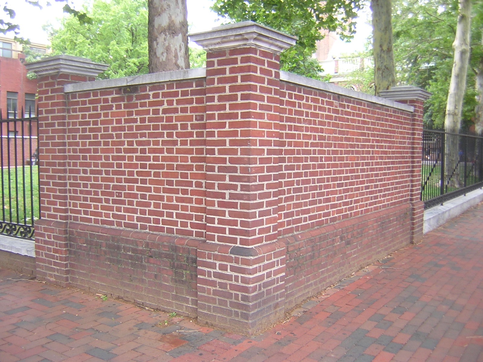
There was a bit of tip-toeing around what should be done with the elephant in the room - a parking lot that sits discreetly behind a red brick wall at the west side of the park. One of the presenters noted that turning the parking lot into part of the park would increase the size of the park by 50 percent. However, the National Park Service has stated from the beginning - very nicely - that the parking lot is out of scope for this project.

The presenters did discuss expanding the park in a tentative way that I hope didn't offend anyone, and they offered drawings of lesser takings from the parking lot that would improve the sightlines into the center of the block.

I say what I'm about to say with a twinge of regret, because I do think this is a model parking lot - it essentially disappears, in a nice way, behind a red brick wall. I wish every parking lot in Philadelphia looked this good. Very few of them do.

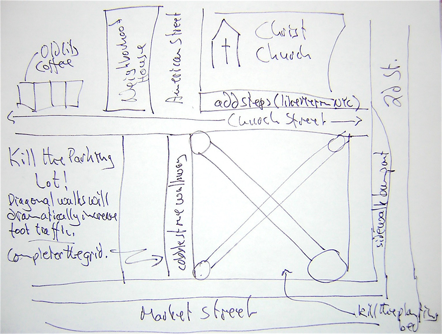
However, having given the matter some thought, I strongly support turning the parking lot into park land, for several reasons. First, this is a small lot in a crucial location that should be devoted to active people and not sleeping cars. Second, these drivers have alternatives in very large garages at the mall and on Second south of Chestnut. Third, turning the lot into parkland would provide a lot more room for people to enjoy themselves outdoors right in the center of Old City. Fourth, it would open up the block in a dramatic way that would let people see, before they stepped into the park from Market or Second, the potential for further walking adventures beyond the park, to the north and the west. Currently the rather complex web of streets within this block is not particularly visible until you get through the park and hit Church Street - the main drag, but hardly the only option for an interesting walk.

I hope the National Park Service will reconsider its position.

Diagonal Walkways
The presenters showed us drawings for four main options. I liked pieces of each of them, and pulled them together into what I suppose we could call option five - the rather clumsy drawing at the top of this story.

First, I think the park needs two strong diagonal paths, from the southwest to the northeast, and from the southeast to the northwest. These will be good for the park itself, and for the whole neighborhood. The survey came up with a figure of 20 percent of respondents who never go to the park. This is a terrible number, and the way to fix it is to allow people walking - residents, workers, tourists - to use the park as a shortcut to their destination.

There seems to be a lingering idea that a park should be solely an oasis for quiet contemplation, and that foot traffic shuffling through would be a distraction for those who have come to meditate. If you look at Washington or Rittenhouse Square, you'll see that they both have strong diagonal paths. And if you stand at the northeast gate of Rittenhouse Square, at 18th and Walnut, around 8:30 on a Tuesday morning, you'll just about get run over by the people walking through the park on their way to the office. This is not a conflict with other uses, it is a complement.

In The Death and Life of Great American Cities (1961, pp. 96-97), Jane Jacobs analyzed Rittenhouse Square in detail and came to the conclusion that the square's secret to its success was the variety of users who appear in the park over the course of the day.

Jeff Speck, in his book Walkable City (2012), likes to talk about the importance of bringing back the useful walk - walking to the office, or walking to pick up groceries, possibly at several different stores (say, in Rittenhouse, coffee at La Colombe, bananas, clementines, and arugula at Sue's, and cheese and maybe soppressata at Di Bruno's).  Walking should not be simply a leisure activity. It can also be a useful way to get around.

I think people - particularly our leaders - have trouble with this idea, just as they seem to have trouble seeing a bicycle as anything other than a leisure-time toy. The pattern of bicycle commuting and utility bicycling throughout the day is firmly established in certain parts of Philadelphia. And certainly it's not a secret at this point. I just think a lot of people have trouble processing the information, let alone acting on it.

And I think I know why. Jarrett Walker, who is consulting on the redesign of Philadelphia's bus network, has an interesting blog post on elite projection. This is simply the idea that the well-to-do and influential people in our society imagine that everyone else is just like them, or wants to be just like them. As he points out, many, many problems flow from this lack of vision.

Anyway, the strong diagonals should be very good at getting people into the park, and they should also encourage people to see how permeable this block is. And this block is only part of a larger, currently unintegrated, circulation pattern that, if it ever gets hooked together, would allow people to get around entirely on byways and, with the exception of crosswalks, avoid the highways. This system of walkways and alleys is prepared to run from the mall on Fifth Street down to Front Street, and from the Arch Street Meeting House to Old St. Joseph's Church, below Walnut.

Opening Up to Market Street
Coming back to the park itself, let's have a look at proposals for the perimeter of the park, starting with the south side, by Market Street. The actual park is at present set well back from Market, with much of the additional space taken up by a planting bed. I personally think the original designers of the park saw this as a mashalling yard for tourists. You can stand at the fence and gaze at Christ Church on the other side of the park's large lawn, maybe take a picture. Then you can walk through one of the park's two gates, which stands inconspicuously at the west edge of the park, next to the brick wall for the parking lot. You can then walk up a brick path to the gate at the north side of the park and, if you want, cross the Belgian block of Church Street and enter the church.

So the whole park, on its most heavily trafficked side, is essentially hiding. Time to open things up a bit. There are a number of interesting proposals about how to do this, but I do think one thing is quite clear. This park needs a gate at the corner of Second and Market. Which by the way is only a few steps from the Second Street stop of the Market-Frankford line, and less than half a block from stops for six different bus routes (5, 17, 21, 33, 42, 48).

Unless you're moving a piano, you really don't need to drive to Old City. But however you get there, the corner of Second and Market is the natural front door for Christ Church park. At present there is no gate on this corner.

Sidewalk Bumpout on Second Street
The design team also suggested bumping out the sidewalk on Second Street, roughly from Church Street down to Market. Engineers have been consulted, and we are assured that this can be done without materially affecting the flow of motor vehicles down Second Street.

Steps for Sitting on the North Side of Church Street
The design team also recommends adding steps to the north side of Church Street. You could use these steps to walk up to the church's grade level, which is a bit higher than the surrounding area, or you could use them to sit on; this happens quite a lot on the steps of the Metropolitan Museum in New York City. I think the steps the design team proposes would work well.

The team is also proposing a lower wall on the north side of the actual park. These two changes would serve to meld the Church and its yard, Church Street, and the park itself into a more organic whole.

Back to the Parking Lot
Okay, back to the west side of the park. Another advantage of removing the parking lot is that it allows you to move the current north-south walkway further to the west, so it's on line with American Street to the north. There was a lovely rendering of this new walkway, paved now in cobblestones instead of brick, and looking for all the world like an eighteenth century Philadelphia street, shaded by the mature trees that are already present in the parking lot.

This new alignment for the walkway allows people to see from Market Street that the block has an interior north-south street, and from the park they will also be able to see Church Street running east to west, and intersecting at the northwest corner of the park.  That's not the whole internal grid on this block, but I think it's enough to create an invitation to explore. 

About Those Pink Stickers
At the end of the meeting, printouts of the four design options were put on tables, and the members of the audience, who had each previously been provided with several small stickers, some green and some pink, were asked to show their approval of particular design elements by placing a green sticker on things they liked, and a pink sticker on things they didn't like. I placed my stickers, chatted with a number of people, and at the end of the session I walked around and had a look at where the various stickers had descended.

On the plans that still had the parking lot at least partially intact, the lot looked like a leopard with pink spots.


Parking lot gate. Unlock the value.

See also The Invitation, The Future of Christ Church Park, Permeable Blocks.

Sunday, September 9, 2018

Jane Jacobs Was a Bicyclist

She Commuted by Bike in Manhattan in the 1950s

Boardwalk, Asbury Park. Not Jane's bike.

Jane Jacobs didn't drive, but her husband, Bob, did. They had a car, which largely sat in a garage on Greenwich Street, near their home at 555 Hudson Street in Greenwich Village, and got used mainly for vacation trips. For a number of years, the family car was a Fiat Multipla, an odd-looking little van that was famous in the Jacobs family for a highly temperamental fuel pump. Later, as they were moving to Canada, they purchased from friends a VW bus that was on its third engine.

Jane Jacobs didn't dislike cars. She just thought there were too many of them. And she hated what cars were doing to cities: "Traffic arteries, along with parking lots, gas stations and drive-ins, are powerful and insistent instruments of city destruction. To accommodate them, city streets are broken down into loose sprawls, incoherent and vacuous for anyone afoot. Downtowns and other neighborhoods that are marvels of close-grained intricacy and compact mutual support are casually disemboweled." (Jane Jacobs, The Death and Life of Great American Cities, 1961, p. 338.)

Jane the Cyclist
Jane got started cycling as a child in Scranton, Pa., where she competed for saddle time on two tricycles in a family that eventually included four children. She was one of the few in her era who continued bicycling into adulthood - the nadir of American bicycling may be considered the 1930s to the 1960s, and she cycled right through them.

(This article relies heavily on Robert Kanigel, Eyes on the Street: The Life of Jane Jacobs, 2016. For the paragraphs above, see pp. 25, 114, 207, 261, 262, 277.)

Fortunately husband Bob was also an avid cyclist. When he was nineteen years old, in 1936, he toured through Europe by bicycle, even spending some time in what was then Nazi Germany. (Kanigel, p. 95.)

In addition to practicing architecture (he specialized in hospitals), Bob taught and wrote. Here's something from one of his articles: "We run the risk," he wrote, "of letting verbalized symbols overwhelm, smother and even negate the direct data actually supplied by our senses." (Kanigel, pp. 97, 123, 281.)

I think I like Bob.

Jane was also no stranger to bicycle touring. In 1940, she had taken a week-long bicycling trip in Quebec with her older sister, Betty. So it should come as no surprise to us that, after their wedding in 1944, the couple found themselves on a cycling honeymoon, riding through northern Pennsylvania and southern New York State. (Kanigel, pp. 25, 81, 96.)

In the early days of their marriage, they would go "hitch-hiking with the fish," as she put it. Here's what her biographer, Robert Kanigel, has to say: "they'd load their bikes on the train, get off somewhere within cycling distance of a fishing port, and, with their beat-up bags, hitch rides on fishing boats plying East Coast waterways. No reference to what Jane called this 'intricate network of unofficial transport' appeared in any atlas or tourist map. They made no hotel reservations, yet always found someone to take them in. In a little town on Pamlico Sound in North Carolina, it was the owner of a local shrimp-packing plant. In Maine, it was the island butter maker and her lobsterman husband." (P. 135.)

When at home in New York they would go for Sunday bike rides in the city, and after they had children, the little ones would come along too. (P. 135.)

But it is Jane's bike commuting that is, for me, the most arresting part of this picture. After all, Americans have historically viewed the bicycle primarily as a recreational vehicle. There was an awareness of the concept, even though very few adults were riding by this time. On the other hand, riding a bike to work between Greenwich Village and midtown Manhattan, in the starchy, gray-flannel suit days of the 1950s - that has a decidedly transgressive feel, at least to me. I love it.

Jane kept her bike parked just off the kitchen in their home on Hudson Street. It was accoutered with a wicker basket attached to the handlebars. In the morning, wearing conventional office attire, "sometimes even pearls," she would get the bike out and pedal through highly congested streets to her office at Architectural Forum, in Rockefeller Center - all this without bike lanes or even a helmet. Standard comments were "Get a horse!" and "Watch out, girlie, you'll get hurt." (Pp. 134-135, 200.)

Jane the Street-Fighter
Jane Jacobs is of course mainly known for her epochal book, The Death and Life of Great American Cities. She is also remembered as an early and important community activist. She fought a whole series of battles in defense of her West Village neighborhood, and in two of them she faced off directly with uber-highwayman Robert Moses.

They were oddly matched antagonists. Moses was the quintessential insider, amassing vast power without ever getting elected to anything. And there was Jane, the quintessential outsider, organizing her neighbors to crack open the doors of power and give residents at least a little bit of say about what happened to the place where they lived. It was a long time ago, and it's difficult to imagine today how radical this whole concept of community involvement was.

There's something called asymmetric warfare -  it's one of the reasons we lost in Vietnam - and I think the asymmetry between Moses and his world and Jacobs and her emerging world was one of the keys to her success. In the two battles she had directly with Moses, over Washington Square Park and over the proposed Lower Manhattan Expressway, she won. I think Robert Moses just didn't see it coming. (See Kanigel, chapters 15 and 17.)

I've searched around for something, anything, that Moses and Jacobs had in common. And I did find one thing. Neither one of them drove. Bob Jacobs drove Jane, and Bob Moses had a chauffeur. He never learned to drive.

I think there's something ironic about the fact that, in these two crucial battles over making space for more cars, neither side was led by a motorist.

(In 1958 Jane Jacobs wrote a story for Fortune magazine that provides an early summary of her ideas. I found it online; it's quite a lot of fun, and substantially shorter than the book. To see it, click here.)

See also Cars and Bikes - the Back Story, Why Are European and American Bicycling So Different?

Wednesday, August 1, 2018

The Invitation

Christ Church Park, An Underperforming Asset


The corner of Second and Market. No gate.

So maybe we should ask people to come into the park. Just a thought. It's a nice park - I've often admired it walking by, on either Market or Second, on my way to somewhere else. I've hardly ever gone inside the park, and when I have I wasn't quite sure what to do there.

Let's face it: I've been coddled by Rittenhouse Square, where there are benches, other people, yadayada. Oh, yes, and there are ways into Rittenhouse Square.

How do you get into Christ Church Park? It's almost a secret. Is there an entrance at or near the corner of Second and Market? No. Think about Rittenhouse Square and the corner of 18th and Walnut, with massive quantities of pedestrian commuters in the morning and evening rush, bike messengers hanging out all day, socializing and waiting for their next call, various solicitors for religious, political, and other causes. The occasional odor of marijuana. Nothing like this happens at Second and Market. There's no gate there, you know.

Gate on Market Street, recessed in midblock.

There are two entrances to Christ Church Park, and frankly they're almost hidden. There's one on Market in the midblock, at the southwest corner of the park. The other one is at the northwest corner of the park, near the entrance to Christ Church. The two gates are connected by a brick walkway, the only path in the park.

The Market Street gate and the walkway.


Gate on Church Street.

Urbanist Jan Gehl likes to talk about the invitation. If you want people to come into your park, you need to invite them in. (See Jan Gehl, Cities for People, 2010, pp. 15, 17, 21, 236-237.)

View from Church Street gate, Christ Church across the street.

Okay, so let's assume you're in Christ Church park. What do you do then? Good question.

I'm a simple guy. My main park activity is hanging out. I don't need rope courses or zip lines. A place to sit would be nice. The park currently has five stone benches strung along the walkway. They do not have backs or armrests, but they are backed by a brick wall. Here's a picture.

Four of the five stone benches. The walkway. The brick wall.

Behind the brick wall, by the way, is a parking lot. It is virtually invisible. I wish all the parking lots in Philadelphia were as demure as this.

This parking lot is on line with American Street. 

Given the configuration of the park as essentially a pilgrim's path to the church, it is perhaps not surprising that park utilization leaves something to be desired. Dog-owners walk their dogs here, and even that has its ins and outs. This is a National Park Service park, and the Park Service requires dogs to be on-leash at all times. It's in the Code of Federal Regulations:  36 CFR Chapter 1, Section 2.15(a)(2).

Reimagining the Park
I picked up these tidbits at a July 18 meeting in Christ Church's Neighborhood House, next door to the church itself. On the fourth floor, in an auditorium that used to be a gym (there are still basketball-court markings on the floor), I watched and listened as various speakers discussed various aspects of the park.

All this gabbing was in service of a project sponsored by the Old City District: Reimagining the park at Second and Market Street.

Ideas? Yes, I Have a Few
Here are a couple of ideas off the top of my head.

My top priority. Figure out how to get little kids and their moms and dads into the park. You definitely want them in the mix of park users. They bring a whole new and very positive vibe.

Just look at the statue of Billy the Goat in Rittenhouse Square. The goat is the center of a seating area largely but not exclusively occupied by small children and their parents. This place is so popular with kids that, after a century, a literally worn-down Billy is retiring to a nice pasture across the street in the Philadelphia City Institute Library. He will be replaced by Billy Jr., an exact replica.

Second idea. Plan for a mix of uses. In The Death and Life of Great American Cities (pp. 96-97), Jane Jacobs explains the secret of Rittenhouse Square's success. Because it borders a residential district and a commercial district, the park draws different people at different times of day. Aside from small children and their parents, and the old people who like to sit on benches and watch them, you have pale-faced office workers who come to get some sun and exercise while walking on the park's ring path. The benches welcome people eating takeout lunches.

I could go on, but you get the idea.

So here are some physical changes that would undoubtedly make Christ Church Park more popular.

- More gates, better placed.

- Diagonal paths. These would encourage people to shortcut through the park. A valid use to my mind (I certainly do it a lot myself), and some of the people passing through may sit down for a few minutes, rest their feet, and look around.

- A water feature. Philly has lots of great water features, none better in my estimation than the two at Sister Cities Park by Logan Square (talk about child magnets). I personally think the water feature at Christ Church should include a watering trough for horses.

- Interpretive plaques. And here's why we should have a horse trough. Somebody needs to step up and educate tourists and locals about the history of the nineteenth-century city they are standing in the middle of. Explaining to people what a horse trough is could be a good place to start.

Why All the Low-Hanging Fruit?
As I learned at the information session, Christ Church Park is a child of the 1960s. The Park Service wanted to create a view shed for the church, so it pulled down the buildings where the park now is and created a very pretty space that would allow tourists to stand at Market Street, where the sidewalk has been widened and a raised planting bed with low walls appropriate for seating has been provided. (These walls currently sport a don't-sit-on-me rail running along the top.) Tourists could view Christ Church from a distance and then possibly walk on the walkway at the west side of the park to view the church exterior close-up and possibly even go inside the front door, just a few feet from the park's northern gate. Any other uses by pedestrians do not seem to have been in the program.

That's simply how people were thinking then. Take Mies van der Rohe's iconic Seagram Building, on Park Avenue in Manhattan. A product of the 1950s, it stands in magnificent isolation behind a very effective view-shed plaza. Later on, people did get the idea that maybe there should be, you know, people in the plazas, but in the beginning it was definitely look but don't touch. It might be a step too far to say that the only pedestrians welcome were architectural photographers. Or it might not be a step too far.

The view of Christ Church from Market could actually be improved by lowering the fence. New York City's parks department has a program called Parks Without Borders; it does advocate in certain situations for taking down fences entirely. I wouldn't do that here because I think the moms and dads will want some perimeter definition to help keep their little ones from wandering out into the middle of Market Street.

Learning from Love Park
Part of Old City District's reimagining process will be looking at ways to further civilize the streets adjacent to the park.

I watched this mission civilisatrice (as the French would call it) fail at Love Park. I love the new Love Park itself, but nothing was done about the surrounding streets despite promises and hints.

I'm still angry about Love Park, but I'm working resolutely to set that anger aside and focus on the opportunities presented by Christ Church Park. I think, with a little help from well-meaning people, the park could raise its game significantly without spending a lot of money.

There's an open design workshop at the park Wednesday, August 8, from 2 to 7 p.m. The workshop will be at the farmer's market, which is next to the church.

There is naturally a page on the Old City District's website. Linked from the page are a survey and the slide deck from the July 18 presentation. Click here to view.

See Do We Secretly Want Ugly Cities and Dangerous Streets? Also Road Diet by Love Park - a Natural Experiment.

Monday, April 2, 2018

Which Side Are You On?

Sometimes It Comes Down to This

2100 block of South Street.

I'm on the left. And I hope you are too. Call it eye candy. Call it visual interest. My eye goes to the facade on the left. There's something to look at. The one on the right looks like it's basically trying to disappear, and it's doing a pretty good job.

As urban guru Jan Gehl puts it, "If ground floor facades are rich in variation and detail, our city walks will be equally rich in experience." (See his book Cities for People, p. 41.) Gehl goes on to suggest that thriving commercial streets all over the world tend to have a new shop or booth every 16-20 feet, which means that someone strolling along will see something new every five seconds or so (p. 77).

Stretches of certain Philadelphia streets do pretty well at this test - Walnut and Chestnut of course, parts of South Street, both east and west, East Passyunk. There are others.

Residential Streets
But what about residential streets? Are we doing enough to keep the walk interesting? I'd say yes and no. Some blocks in Center City are so beautiful that I don't mind a certain sameness. Take the 1800 block of Delancey, with its facing rows of gorgeous Georgians. Even here, though, not all the buildings are in the Georgian style, and if you look a second time you'll notice that the Georgians are not all identical. There is a pleasing variation in the details of the facades. And it doesn't hurt to have a Frank Furness building plopped at each end of the block. Two very different buildings, both very different from the Georgians.

Other blocks can be more diverse and still read as a coherent and pleasing whole, with buildings of different size and use and age finding a way to meld together. It's a balancing act, but to my mind a touch of chaos is preferable to dead conformity.

As Jane Jacobs notes, this is the way cities lived before the clear-cutting of urban renewal: "A successful city district becomes a kind of ever-normal granary as far as construction is concerned. Some of the old buildings, year by year, are replaced by new ones - or are rehabilitated to a degree equivalent to replacement. Over the years there is, therefore, constantly a mixture of buildings of many ages and types. This is, of course, a dynamic process, with what was once new in the mixture eventually becoming what is old in the mixture." (See The Death and Life of Great American Cities, p. 189.)

If you're looking for an example of what a street like this can look like, take a stroll down the 1900 block of Panama.

And if the architects are having trouble getting the mix right, we can always bring in the artists. A blind wall can bring life to a whole street with the help of a mural (walk by 17th and Waverly), or a mosaic by Isaiah Zagar (see this story on the 800 block of Pemberton).

Or street furniture like trash cans and utility boxes can become accent points: Send in the Mural Arts Program or students from the University of the Arts. (See What Should We Do With the Humble Dumpster?)

I have one more idea. Let's take a cue from the abstract expressionists and try some color field painting.

Yellow Houses
Oops. It looks like we're already doing this. Have a look below. Without the yellow facade, this would probably be a car ad. With the yellow, architecture wrests back primacy from the automobile.

And, as an added treat, just this once, the building owns the street down to its toes. Normally, parked cars drown the bottom half of the ground floor. I think this state of affairs does untold damage to the pedestrian experience, and I think we're so used to it we don't even notice what we don't have.

11th Street at Waverly.

As Jan Gehl notes, the ground floor is overwhelmingly what pedestrians look at. But they do look up occasionally; Gehl suggests the person on the street can relate pretty well to the first five floors of a building (p. 40). Think about the Sistine Chapel ceiling, which is 68 feet above the ground. People can see it just fine. Michelangelo made sure of that.

So our new corps of color field painters should treat the whole facade as their canvas. Let's pull back a bit from this building and see what it looks like from Waverly.

The whole building.

Now let's pull a bit more back up Waverly, even though it's trash day. An accent point can pull together a whole lot more than itself.

From Waverly near Jessup.

Here's another yellow building. I've been passing it for years, and a few days ago, for the first time that I know of, the parking spot in front of the building was empty. And I had my camera with me.

2100 block of Locust.

And here's another.

2000 block of Waverly.

One more. You'll notice that the street trees can be much more than bit players, if you can see them.

25th at Panama.

Let's look at some other colors.

Other Colors
Blue, for instance. This one is across the street from Frank Furness's Thomas Hockley house. (For more on Frank Furness in the Rittenhouse area, click here.)

21st Street south of Walnut.

I call this one the Jolly Green Giant.

Naudain at 24th Street.

I really like this one. It's a little hard to find. Addison Street in this block is a stub that doesn't open onto either 10th or 11th. You need to walk down Waverly and then turn onto a little north-south stub called Alder, and a few steps will take you to Addison.

1000 block of Addison.

Plenty of Painted Buildings
At the risk of stating the obvious, there are plenty of painted buildings in Philadelphia. Very few of them look like the house on Addison Street above. I'm trying to make the case for a bolder use of color. And the good news is that I can do it by walking around and taking pictures of stuff that's already there.

Don't get me wrong. There are a lot of lovely pastels around town - two of the yellow houses above are pastels. I particularly like them when they use features like doors, windows, and the cornice as accent points.

Red: A Special Case
Years ago S. Weir Mitchell wrote a novel about Philadelphia called The Red City. It's still red. We've got plenty of red brick buildings, including the new Museum of the American Revolution.

So why would you paint a red brick building with brick red paint? Do you really think we don't notice the difference?

Painting red bricks red displays, to my mind, a certain lack of imagination. I understand the desire to fit in, and I understand that the paint may be covering a myriad of flaws, and I'm not opposed to painting brick. But really, that color? You're not fooling anyone. The facade lacks the texture of brick and the variety that comes with the contrasting color of the mortar. Next time, have a look at chrome yellow.

Plaque remembering S. Weir Mitchell, 1500 block of Walnut.

See also City Beautiful Sprouts on Cypress Street, Gordon Cullen and the Outdoor Floor, Putting Some Park into Old Parking Lots, Do We Secretly Want Ugly Cities and Dangerous Streets? 

Tuesday, January 16, 2018

Outflanking City Council

Sunset Avenue Pavilion, Asbury Park.

Jane Jacobs had a lot of interesting ideas. Here's one of them.

"Thus, although in many cities councilmen are apt to be local 'mayors', this is unusual in New York, where city councilmen's constituencies (about 300,000 people) are too big for the purpose; instead, local 'mayors' are more frequently state assemblymen who, purely because of the circumstance that they have the smallest scale of constituencies in the city (about 115,000 people) are typically called upon to deal with the city government. Good state assemblymen in New York City deal much more with the city government on behalf of the citizens than they do with the state; they are sometimes vital in this way as city officials, although this is entirely aside from their theoretical responsibilities. It is an outcome of district political make-do."

This is from The Death and Life of Great American Cities, 1961, p. 423 fn.

I started thinking about what such an arrangement might mean in Philadelphia today. Currently City Council is pretty much impervious to the pleas of constituents that it does not want to hear. Councilmanic prerogative - the ability of a district Council member to stop pretty much anything in his or her district - essentially gives the possessor of a district a position that is unassailable by frontal attack. Here in the city of brotherly love, the Quakerly influence means that such an attack would not generally entail brickbats or rotten tomatoes, but rather attempts to change the council member's mind - appeals to reason, appeals to emotion.

This means that proponents of change on a variety of issues - including my two favorites, parking and bicycling - are basically dead in our tracks. Our representatives are sitting on the parapets of their castles, looking down at us and laughing.

It would be nice to think that we could turn them out at the next election, and in a number of cases that may be possible in 2019, but many of the most problematic are in safe seats. Indeed, the Council seat in West Philadelphia looks like it has become a hereditary office. Perhaps we should start calling it the Duchy of West Philadelphia.

Jacobs, however, seems to be showing us another way - a flanking attack.

If state legislators started weighing in on neighborhood issues, what would that do? I don't think Councilmanic prerogative would evaporate overnight, but it might embolden our mayor to say, "Look, buddy, I know you're absolutely opposed to bike lanes, even though you claim to be in favor of them, but I have an Assemblyman who says he is speaking for the constituents you refuse to represent, and he says go ahead with the lanes. So I'm going ahead."

A dream, perhaps. But here's another way a state legislator could help. I got this idea from my brother. We were talking about Jacobs and her idea of the assemblyman mayor, and he mentioned that the City Club of New York had allied itself with a state senator on an interesting project. (John does a fair amount of volunteer work for the City Club.)

A long time ago, a new baseball team needed a new ballpark, and so the Mets got Shea Stadium. This took an act of the state legislature because Shea Stadium is built on city park land, and, without putting too fine a point on it, park land is supposed to be for parks.

Along with the stadium there came various ancillary uses, including parking lots.

A few years ago, the forces of Mammon decided to build a shopping mall on one of the lots. Quite a few people thought that the state legislation only authorized a stadium and related facilities, and using the law to build a shopping mall was a bit of a stretch. The City Club and a number of other groups decided to sue, and State Senator Tony Avella, who represents quite a bit of this part of Queens, agreed to be the lead plaintiff, or petitioner.

The case was called Avella v. City of New York. In June 2017 the New York State Court of Appeals ruled in favor of the petitioners. (For a story in the New York Times, click here. For a story in the New York Law Journal, click here.)

I'm thinking of the recent lawsuit in Philadelphia, which sought to end parking in the Broad Street median. The suit was dismissed. I wonder whether the case would have gone further if the lead plaintiff had been an elected official.

I'm also thinking of a number of other places around the city where a similar approach might work. Currently uppermost in my mind: Washington Avenue.

Sunset Avenue Pavilion, Asbury Park.

See also At Least It Makes People Laugh, My Life in Fairmount Park, Vision Zero in Philadelphia.