Why Is This Square in a Class by Itself?
 |
| Rittenhouse Square, circa 1890. |
I'm not a believer in the Great Man theory of history, any more than I believe in the inevitability of progress. But the headliners have their uses.
Take Paul P. Cret, for instance. In my imaginary museum of Philadelphia's architecture and urban design, I place his portrait on the wall between Frank Furness and Ed Bacon.
Cret fills a gap for me. I had a sense of Frank Furness and the railroad city after the Civil War, and of Ed Bacon and his struggles after the Second World War to bring the as-yet unnamed topic of urban design to Philadelphia.
But what happened in between - say from 1903 to 1945? I just didn't have a good sense of it.
Rise to Eminence
Cret arrived from Paris in 1903 to teach architecture at the University of Pennsylvania. He came directly from the renowned Ecole des Beaux-Arts, and as he looked at the state of planning and design across Philadelphia, he saw fertile, well-watered soil that needed the addition of a few seeds. And so he got to work. (David B. Brownlee, Building the City Beautiful: The Benjamin Franklin Parkway and the Philadelphia Museum of Art, 2017, p. 8.)
In addition to his teaching duties, Cret pursued a private practice, landing his first major commission - the Pan American Union building in Washington, D.C. - in 1907. Also in 1907, the Fairmount Park Art Association appointed Cret as one of a small group of architects tasked with developing a comprehensive plan for the nascent Benjamin Franklin Parkway. (Brownlee, pp. 22-23.)
As if he didn't have enough to do, Cret also became a patron of the city's T Square Club, where a design workshop offered advanced instruction to practicing architects and also draftsmen in architectural offices. (For a brief but very informative biography of Cret, click here.)
After his 1907 appointment to the design committee for the parkway, Cret's next step to power and glory in Philadelphia's emerging structure for city planning came in 1911, when he was appointed to the newly formed Art Jury. (Brownlee, p. 51. The Art Jury, now the Art Commission, had and has considerable authority over aspects of the city's built environment. Professor Brownlee kindly directed me to the Art Jury's first annual report, covering 1911, which is available online. To see it and subsequent annual reports, click here.)
City planning was in the air in America, and particularly in Philadelphia. The Third Annual City Planning Conference took place in Philadelphia in 1911, and the city's department of public works prepared a 30-foot model of the Benjamin Franklin Parkway, which was still in the midst of its rather turbulent development process. Frederick Law Olmsted told Philadelphians that their city was "the farthest advanced in the country ... in city planning." (Brownlee, p. 27.)
The Architect and the Square
In the midst of all this, Paul Cret redesigned Rittenhouse Square. He didn't just redesign it, he married it, a relationship of nearly constant attention that lasted from the initial design process of 1913 through the first wave of construction in 1914, a lengthy separation while Cret served in the French army during World War I, a second wave of construction after the war, and then on, nearly to the time of his death in 1945.
The square was clearly a pet project, his close and sustained attention made easier by the fact that his practice's office was only three blocks away.
Before we dive into some of the nitty-gritty, I'd like to set out three points, which I will illustrate in greater detail as we go on.
(If you're interested in all the nitty-gritty, there is a master's essay from the University of Pennsylvania: Eric Anders Baratta, The Performance of History and Design in Paul Cret's Rittenhouse Square, 2002. Baratta did an amazing amount of research in some very rich archives, and the story you're reading relies heavily on that work. When it comes to interpretation, as you will see, he and I frequently part company. All the illustrations in this story are from the master's thesis. To see the whole thesis, click here. The photograph at the beginning of this story is figure 33. For the paragraphs above, see particularly pp. 1, 33-36.)
First, Rittenhouse Square is not a French formal garden. I think it is better analyzed as an English garden refracted through a Parisian lens. At any rate, the antecedents for Rittenhouse Square are clearly multiple.
Second, although promotional literature at the time suggested that the 1913 proposed revisions to the square were inspired by the Parc Monceau in Paris, this is simply not true for the physical plan. If there must be a single source of inspiration, Baratta suggests that the Jardin du Luxembourg would probably be a better candidate. (Baratta, pp. 18-19, 39-40.)
Third, the park as you see it today does not exactly reflect the park that Cret built in 1914. If you want things exactly the way they were, you're going to have to bring back a lot of gravel.
One final thought about Cret: His own vision for the park clearly evolved over time - for instance, the 1914 construction plan was not his first plan (p. 36). One of Cret's strengths was his flexibility. Another was fidelity to what really matters.
The Lay of the Land
Let's have a quick look at Rittenhouse Square and its development before Cret came on the scene.
The Southwest Square was one of the five squares in William Penn's 1682 plan of Philadelphia, but for the first century or so nothing much happened. Then an expanding city came closer, and the pace of change picked up.
In 1816 a wooden fence was built around the square; in 1825 Southwest Square was renamed after David Rittenhouse, a versatile engineer and scientist best known as an astronomer, and also first director of the U.S. Mint. In 1852 the wooden fence was replaced by one made out of iron. (Pp. 8-9.)
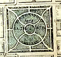 |
| 1862. |
An 1862 map (see Baratta, figure 6) shows the layout of Rittenhouse Square: two concentric circular paths, along with a radiating series of paths that extended from the inner circle out to the corners and the sides of the square. These radiating paths are not straight; they curve, or possibly meander, quite a bit, suggesting that people came here for a walk in the park and were not seeking the shortest path from one side of the park to the other.
By 1875 (fig. 28) it appears that the radial paths have been straightened a bit, but the overall layout seems the same.
 |
| 1875. |
By 1887 (fig. 29) the peripheral access paths have been reorganized into something more like what we have today, aligning them somewhat better with the surrounding street grid - at least at Locust Street. And the diagonal paths have been turned into direct shortcuts, as they are today.
 |
| 1887. |
Historical Models
Baratta suggests that Rittenhouse Square is best analyzed as a residential square, and he describes the four models that were available to Cret (fig. 1). First is Centric, top left. It is essentially a flat, open space with a statue in the center.
This is what the Place des Vosges in Paris looked like when it was created in the seventeenth century. (The statue was of Louis XIII.) Place des Vosges evolved to a more complex design, similar to that shown at top right - the French formal square. (P. 4.)
Additionally there was the English open design, bottom left, and the Romantic, bottom right.
 |
| The four models. |
The pre-Cret Rittenhouse Square clearly has nothing to do with French formal design and fits comfortably within the English tradition.
Parc Monceau
So what happens when Cret shows up? Allow me to suggest that Cret respected what was there and deftly modified it to produce a little gem that is still largely intact today.
How does he do this? He's a well-trained Beaux-Arts architect, so he will start with the existing conditions and the client and then try to develop a workable program.
A comprehensive review of existing conditions in 1913 might well have noted the surrounding neighborhood and its residents, many of whom were quite affluent, and a significant number of whom took a strong and sustained interest in the welfare of the square. So the client was not an individual; it was a group.
This was the sea in which the square found itself swimming; I think it's important to note that none of the other 1682 squares have had such a base of support steadily throughout the years.
Members of the Rittenhouse community had been doing their own thinking about the square. In 1913, "Mrs. J. Willis Martin and Dr. J. William White, two Rittenhouse residents and prominent social figures, formed the Rittenhouse Square Improvement Association (RSIA) to bring about wide-scale changes in the park." (Pp. 16-17.)
In 1912, Mrs. Martin had visited Paris and taken a particular interest in the Parc Monceau. With help from Jacques Greber, she photographed the park. (Greber was a landscape architect educated at the Ecole des Beaux-Arts who was already building a reputation in the United States. A few years later, he was largely responsible for the final design of the Benjamin Franklin Parkway.) Mrs. Martin took the pictures of Parc Monceau home and used them to promote her ideas for Rittenhouse Square. (For Mrs. Martin's exploits, see Baratta, p. 18. For Greber and the design of the parkway, see Brownlee, pp. 30-39.)
Rittenhouse Square simply does not look at all like Parc Monceau, but what she was selling was not so much the plan of Parc Monceau as the spirit of the place. As Baratta puts it, "Parc Monceau provided an ideal example of a small urban park which combined elements of the playground, park, garden and museum enrobed in a landscape with formal variety and classical, if not sentimental, historical referent." (P. 19.)
The Diagonals
As for the actual design of the new and improved Rittenhouse Square, I think the main thing Cret did was to reinforce the already existing diagonal pathways - give them the Beaux-Arts treatment, if you will. We've already seen these paths evolve in the late nineteenth century, to the point where the park was clearly no longer just a place for a midday ramble but was also able to accommodate pedestrians with a destination.
Life After Cret
Since Cret left us in 1945, the biggest changes to the square over the years have continued to focus on the plaza, which was also his most important innovation.
In 1976, landscape architect George Patton undertook a project (pp. 59-61) that resulted in the repaving of the plaza and the promenade, introducing the familiar "banding pattern resulting from the strips used to separate panels of the primary surface material." Baratta just hates this. As he notes, "the strips replace the continuous planar flow of Cret's design with a rigid geometric surface of individual panels."
Frankly, I'm not in love with Patton's pavement scheme. I don't hate it, but it doesn't move me. Kinda boring, actually. But that's just my opinion, and I wouldn't suggest spending money to rethink the whole thing.
The other thing that Patton did, which I like quite a lot, is replace the asphalt that replaced the gravel around the perimeter of the plaza. The new paving is the Belgian block you see today, set in circular patterns around the tree pits. Baratta doesn't like this either. He'd like to go back to gravel, which I just don't see happening.
However, I think Baratta does have a point. The systematic deployment of large, uniform surfaces - light concrete and dark gravel - must have been very dramatic. I don't think I would have found it boring.
Arguments for Restoration
In addition to bringing back gravel, Baratta offers a number of ways to bring the park back more in line with Cret's vision (pp. 61-65). Here are three things where I think some action might be taken.
Stop hanging Christmas lights. The use of heavy equipment - and not just for the hanging of Christmas lights - compacts the soil and harms the trees and other plantings. But rather than canceling Christmas, I suggest we make the illumination of the trees permanent. For quite a few years the blocks of Addison Street from 17th to 19th have wrapped their trees with a permanent display of lights (recently upgraded to LEDs), and they run them all year around. A photographer friend of mine, visiting from Virginia one evening, said he thought the scene looked like a Scotch ad.
I say what's good for Addison would be good for Rittenhouse.
Remove the guard house. I have a conflict here - a friend designed the guardhouse, and I think it's very nice. Baratta is correct in stating that the placement of the guardhouse in the center of the plaza violates Cret's conception of this space as completely open and available for a wide variety of uses.
There is also an issue of semiotics - what does putting a cophouse in the middle of the square say about the square? Its location is very similar to the central panoptic station that Jeremy Bentham developed for his model prison in the late eighteenth century. Unfortunately, the range of vision from our central cophouse is quite limited because of barriers such as balustrades and shrubs, and M. Bayre's Lion. (Hint: Surveillance cameras and a bank of TV monitors work much better.)
On the other hand, there is a tradition of marking the central spot in a square. Place des Vosges had a statue of Louis XIII at its center until the French Revolution.
I'd leave the guardhouse, but perhaps ask the occupants to be a bit more attentive to their housekeeping.
Remove the new path in the northeast corner. This path started life as a muddy desire line. It extends from a park gate on 18th Street, near Chancellor, and runs to a gate on the north side of the square, Commuters from New Jersey were getting off Patco on Locust Street, walking to the square, and looking for the quickest way to their offices in the rapidly developing Market West area. I watched this desire line develop.
The path is foreign to Cret's design. On the other hand, it gives these two gates a purpose, something they didn't have before.
And, if you remove the path, you will simply find yourself with another muddy desire line.
Bigger Buildings, More People
My basic problem here is that I don't believe in the restoration of a historic golden age. I think it's a wrong way to look at history in general, and a wrong way to look at the history of Rittenhouse Square. Paul P. Cret was a very good architect who made creative use of existing materials and was open to changing his plans as circumstances dictated. He made good use Bayre's Lion by moving it to an important, and logical, place in the central plaza from a peripheral location. And, if he had been alive in 1960, when Duck Girl showed up to grace his fountain and reflecting pool, I think he would have cheered.
And, as Baratta points out on page 34, it's just possible that Cret's genius in Rittenhouse Square lies less in the hardware than in the software: "Cret's design takes into account the many uses and users of the square, anticipating the variety of both during different times of the day, week and year. It creates spaces for the activities of groups, both large and small, while at the same time allows places for individual recreation and relaxation. It is defined by what many people consider the formality of its intersecting plaza and promenade, yet its real success is proven in the extemporaneous social theatre of the diverse users of these spaces."
Maybe Mrs. Martin wasn't so far off when she held up Parc Monceau as an example for Rittenhouse Square. Let me repeat what Baratta has to say on the subject: "Parc Monceau provided an ideal example of a small urban park which combined elements of the playground, park, garden and museum enrobed in a landscape with formal variety and classical, if not sentimental, historical referent." (P. 19.)
Still, I think there is an ongoing tendency to focus on the protection and maintenance of a nonexistent French formal garden, and that this focus distracts us from other challenges that are more pressing and more important.
Rittenhouse Square has always been a creature of its neighborhood, and just now that neighborhood is changing very rapidly. The density of our built environment is increasing with every new high-rise, and along with it the number of people who live here, come to work here, or just plain visit because it's a really cool place and why not go there.
All this increases pressure on the fabric of the square, which is most easily seen in the heroic efforts that are required to keep the lawns in respectable shape. We need to start thinking about how to relieve some of that pressure, and I think that involves thinking outside the box of the square.
In my opinion, we need more open space scattered around the neighborhood. When Society Hill was redeveloped, it received a whole series of parklets, walkways, and other bits of open space woven into the new fabric of the area. We don't have that and, given the price of local real estate these days, I don't think we're going to get it.
But we do have a lot of little streets. I think we should look at pedestrianizing a whole bunch of them. This doesn't mean excluding cars and delivery vehicles, but it does mean allowing the streets to have new primary uses. In the residential areas they could be play streets, and in more commercial areas I think they could be used for commerce: I'm thinking lattes and croissants at little tables with red checkered table cloths in the 1700 block of Moravian Street. Retail shops on Walnut could redo their Moravian frontages as entrances; in many cases there are existing doorways and windows that could be unblocked. I think the people around Moravian have the imagination to pull this off.
Call it turning trash alleys into gold.
 |
| The square around 1880 (figure 9). |
See also Unnecessary Spaghetti, Walking to the Free Library, A Few Deft Touches for Back Streets, What We Lost, Do We Secretly Want Ugly Cities and Dangerous Streets?

No comments:
Post a Comment